I am having a lot of fun working on my Scotch-Irish ancestors in Virginia, but I am having trouble picturing when and where they arrived and lived in the mid 1700s. So this blog post is my cheat sheet to help me sort this out. It is both a timeline and a visualization of land jurisdictions.
Before 1738 Orange County was the county seat for all of the frontier of the colony of Virginia....everything west of the settled part of Virginia. Remember when reading the below that the Valley goes UP as you go south. So the lower Valley is in the north close to PA while the upper Valley is in the south.
1732
(above is According to the Book, Settlers By the Long Grey Trail (which can be viewed on Family Search))
According to my Tinkling Spring book:
I am reading The Tinkling Spring Headwater of Freedom by Howard McKnight Wilson. On page 19 I found the following: "Between 1732 and 1738 the lands of the southern shenandoah Valley were settled without formal claim or title. However, the settlers staked out the lands each desired and settled upon them. Then they built their cabins and began to improve upon the lands, in the absence of claims they constituted a "Squatters Right". When Beverley secured the patent covering the same territory, it appears that he dealt peaceably with the settlers. Beverley needed settlers and the settlers needed legal titles to their homesteads, so he and the early settlers traded for an average of one English pound for forty acres. however, when the Augusta County Court was established in 1745 the price to new settlers was almost doubled.
1734 Michael Woods and the group traveling with him are said to have moved to the Shenandoah Valley area about 1734. I found this date in a card file on the internet that was said to be Mennonite records. He actually bought his land as he settled just on the other side of the Blue Ridge Mountains that was in the county of Goochland. So his land transaction is found in the records of Goochland County. Acquired 400 acres in Goochland County "on both sides of Lickinghole Creek a branch of Mechams River." Patents 17, 1735-38, p. 344.
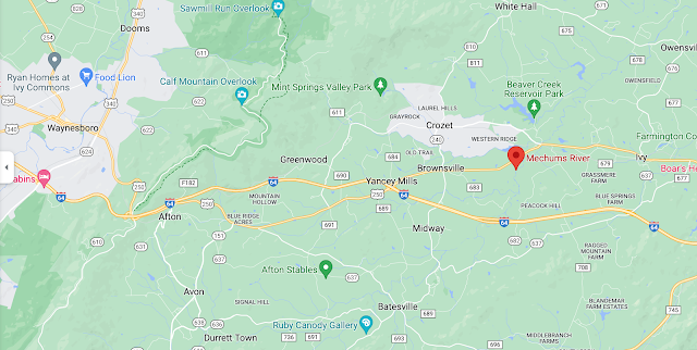
In above map you can see Mechams River just to the east of Woods Gap
Rev. Edgar Woods in his book:
1937 Albemarle County in Virginia : giving some account of what it was by nature, of what it was made by man, and of some of the men who made it (reading on Archive.org) says:
Where was George McNeely living?
I have been trying to put the McNeely group living just east of the Beverley Manor or Borden Tract. But using the water ways mentioned in the deeds it is more likely that they came through the gap in the Blue Ridge Mountains later called Woods/Jarman Gapthat I-64 to settle just to the East of what is now Crozet. In below map red marker just east of Crozet is Mechums River while green marker just above it is Beaver Creek.
1745 Augusta County Court was established
1746-47 Peter Hairston was a member of Reformed Presbyterian Church in Ivy Creek, Virginia
Oh, my. this is fun! When I googled the above church I found a history of the First Presbyterian Church in Charlottesville....this is worth reading! https://faithconnector.s3.amazonaws.com/firstprescharlottesville/files/resources/fpc_history_2nd_edition.pdf
I am not going to copy the entire article, but very exciting is the list of early Presbyterian families:
Mountain area of northern Albemarle County, there were five Presbyterian families: Anderson, Caldwell, Dougherty, Francis, and Pickens. In the Bucks Elbow Mountain area of Albemarle County, there were the following Presbyterian families: Davis, Grier, Kinkead, McCord, McNeely, Owens, Stockton, Wallace, and Woods. In the Rockfish Valley, just to the south, now in Nelson County, there were the families: Dobbins, Miller, Reid, Robertson, and Small. I think we are zeroing in on our group! The Red marker is Bucks Mountain! So you can see that our group was living in the valley just below Bucks Mountain (shown with red marker on below map.)
Mountain Plains Presbyterian Church (Currently a Baptist Church)
The Rev. Mr. Craig, belonging to the Old Side Synod of Philadelphia, arranged for the transfer of the Rev. Samuel Black to the Valley of Virginia. In 1747, the Rockfish Meeting
9
House, and the residents of the Ivy Creek, located near the Ivy Depot, called Mr. Black as their pastor. The groups formed by the early efforts of Mr. Craig met in the homes of Mr. William Wallace, Mr. John Caldwell, and Mr. Michael Woods developed into the congregation worshiping at the Mountain Plains Meeting House at Mechums River. It is interesting to note that Ivy Creek circles Charlottesville, which developed later into the center of population of Albemarle County, from the west to the north of the City at a distance of approximately five miles. Beyond Ivy Creek to the west, Davis Stockton gave his initials, “D. S" to the locality of the meetinghouse, which served the Mechums River and Stockton Fork area of Albemarle County. Mr. Black ministered to all these groups.
I will guarantee that our McNeely family was right there with them! It is my gut feeling that George McNeely and family had settled on the land that Robert eventually bought and had squatted there until Robert got around to buying the land. Remember it was on Beaver Creek quite local to Michael Woods land.
While googling these churches, there was a reference to Rev Edgar Woods book which can be found on line at: https://archive.org/details/albemarlecountyi0000wood
Another book that was mentioned in the history of the First Presbyterian Church of Charlottesville is a book by John Hammond Moore which can be read at Archive.org:
https://archive.org/details/albemarlejeffers0000moor/page/n5/mode/2up


No comments:
Post a Comment