Eno Cemetery Marker Dedication just North of Hillsborough, NC April 22, 2012
I suspect that my Moore ancestors may have been affiliated in some way with the people who were a part of the Preparatory Meeting at Eno. I have not yet done the research to back this "gut feeling" up with lots of documentation. I do know that Richard and Sarah (Perkins) Moore lived in this area with their children between 1757 when they presented a certificate from Exeter MM in Berks County, Pa and were received by Cane Creek MM and 1767 when they were granted certificates to Fredericksburg MM in SC. I will begin a separate blog entry on the families who are named on the back of the below stone marker in relationship to my Moore family in an entry dated May 3 and named: Eno families and relationship with my Moore family.
Richard and Sarah's son, Mordecai, was dismissed from Cane Creek MM in 1758 for marrying out of unity. His wife was Mary Lackey who was the daughter of Alexander and Elizabeth Maynard Lackey. Richard and Sarah's daughter, Abigail, also married out of unity while the family lived in the area near Hillsborough. She was dismissed for marrying out of unity in 1766 when she married Nehemiah Thomas. Daughter, Prudence, was also dismissed for marrying out of unity in 1759. Prudence is named as Prudence Ryan in the will of her father, Richard Moore.
I have found on the below photos, that if you double click, the result is a much better image to view. The maps are very hard to read until one uses the double click to bring them into better view.
 |
| This is the new Marker that was being dedicated. I believe that the stone walls are probably part of the original Eno cemetery. |
 |
This is the back of the marker taken from inside the cemetery.     |
Jeff Palmer reminded me that the following URL has more information about the cemetery and who is buried there:
 |
| This shows the location of Eno Cemetery (Red flag in upper right hand corner) just beyond the Mars Hill Baptist Church on Rt 57 North of Hillsboro, NC.
Of great interest to me at the meeting was the fact that the original land that was deeded from Joseph Maddock in 1756 to the Quaker families to use as a meeting place and for the cemetery lies on the Great Road. It is stated in the deed that it "runs along the great road". It is understood that this would have been the Indian Trading Path. This would have been valuable property since it lay along a principal navigation route.
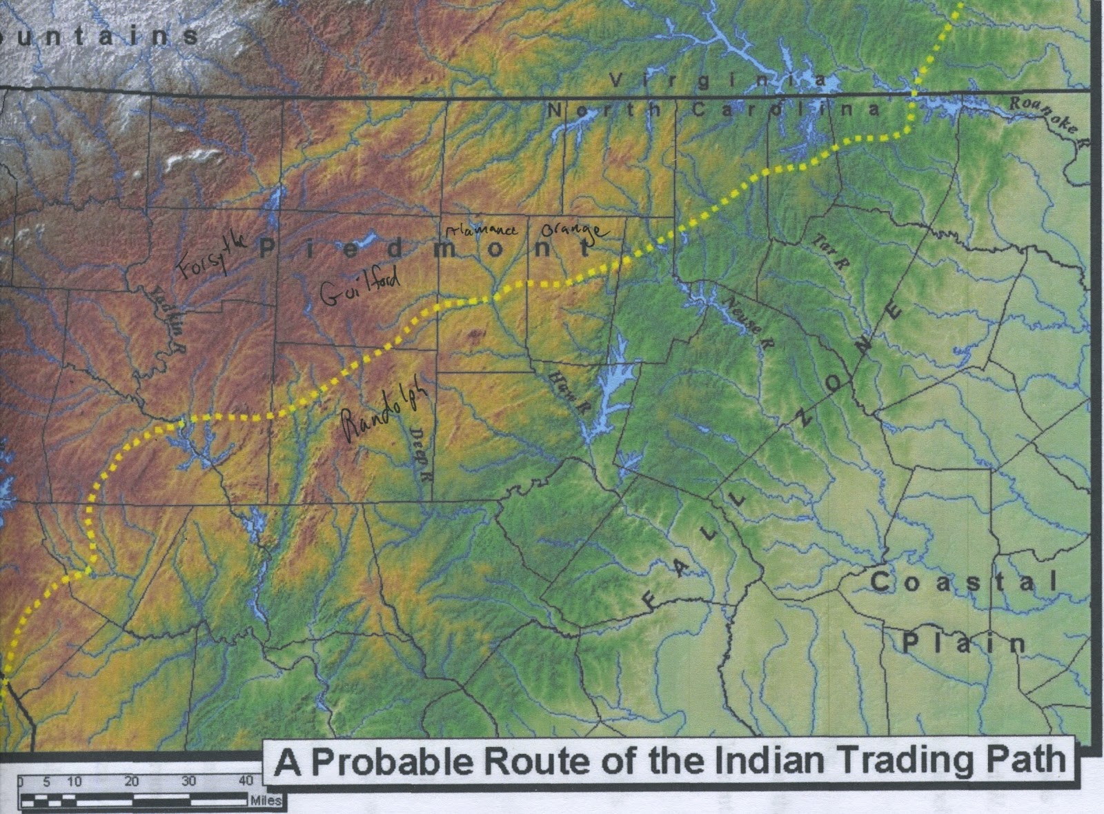 above map taken from dissertation by Gladys Rebecca Dobbs found on line at http://www.unc.edu/~grdobbs/dismaps/dobbs2006disfinalpdf  I took this version of Mouzon's Map from a website on the Creek family who lived here: http://www.moonzstuff.com/cheek/robert1730_oforange_p5.html#map |

The author of the above website has a great list of historical maps on his website at:
My Moore family had moved to Wrightsboro, Ga from the area near Eno before the Battle of Alamance took place in 1771. In trying to explain why they moved I need to put together miscellaneous ideas that I will just add below and try to organize at a later time. But it will be very clear that they were involved with some of the families named on the stone above.
Jimmy Carter in his book The Hornet's Nest says the following about Joseph Maddock on page 45 of his paperback version: " The acknowledged leader of the Friends was a man named Joseph Maddock, who operated a gristmill on a creek....All families in the area carried their grain to Maddock's Mill, knowing him to be an honest man--a rare thing for a miller--whose toll was always what he promised it to be. As did other Quakers, he posted his fees for the various services he offered and considered it a violation of truth to bargain or to modify these charges for a particular customer. Any busy farmer in the area who wanted to continue working at home could send a young boy or slave to the mill and be sure he would get back the right amount of flour, meal, or grits, ground the way he had ordered it. Although silence often prevailed in the regular religious meetings, Maddock liked to talk, so it was natural that most farmers preferred to carry their own grain to the mill and catch up on the local news."
For nearly 13 years Maddock's Mill was the nearest grist mill to the county seat of Hillsboro. In October, 1766, however, Maddock's name and his mill became publicly linked with the Regulators,5 and from that time forward he feared that the mill and his entire North Carolina property would be confiscated by Governor William Tryon.6 The alarmed Maddock and other Eno Quakers swiftly entered for new lands in eastern Georgia;7 and in November, 1767, according to the old Registration of Deeds Book in Raleigh, Maddock conveyed his 20-acre mill seat to Governor Tryon's friend, Capt. Thomas Hart,8 and in July, 1768, he conveyed a 434-acre tract, a sizable portion of his plantation, to Governor Tryon himself.9 Whether or not these two conveyances- were actual sales or thinly disguised confiscations, one cannot say. In any event, by deeds and State land grant, Maddock's lands came into Thomas Hart's hands and Hartford Plantation came into existence.10
Captain Hart (1730-1808) was a Virginian from Hanover County, an adventurer," one of "the men with silver buckles on their shoes" who invariably married heiresses and gradually pushed the less sophisticated pioneer Quakers out of their little stores and inns and acquired their mills and farmsteads – a pattern of polite, ruthless aggression in the Eno River Valley entirely fascinating and chilling to trace today from our vantage point in time.12
(http://www.enoriver.org/eno/Shop/Journals/MillJournal/hartfordmill.htm)


According to a list compiled by Pearl Baker for Story of Wrightsboro, Richard Moore owned lot #46 and #42, and his sons owned: Mordecai Moore lot #7, Thomas Moore #72, John Moore #5. Mordecai also owned acreage outside of town (as many others did): 300 acres on Upton's Creek. It is clear from the date on the certificate from Cane Creek to Fredericksburg MM that the Moore family was firmly established in the Wrightsboro community with the first Quaker group to move from NC to GA. The below maps show where the Moore family would have lived in this time period.


I will be editing this site with more information as time permits. If you have interest in this subject, please bookmark and return to see if I have added anything of interest for you. I hope to include information about family members who moved to the Bush River (Newberry County, SC) area as well as that of Wrightsboro. Also please get in touch (mosesm@earthlink.net) if you have input or see something that I might edit.