Tuesday, December 26, 2023

Willis/Hudson/Hawkins/Butler research

 Pat Clare sent me an e-mail before Christmas that included two links that I don't want to loose.  I want to find time to look at both in January ....and I'll add other things as well.  

https://owsleyfamily.tripod.com/the-ancestry-of-ann-hudson-wife-of-thomas-owsley-ii.html

and

https://www.wikitree.com/wiki/Hawkins-203

I want to put a tree on Ancestry that merges my Hawkins family data base with my Hawkins/Bourne data base....and then perhaps transfer all to my private tree on my computer?  I also want to look at the Hudson dna match that I have that I put down because I could not solve the puzzle.  I could also add some of the information from my Willis book that sits on my desk.

Sunday, December 3, 2023

Friends at the Spring

I had chatted with several people on the Bush River Facebook site when a enthusiastic contributor sent a link for this book:  


I notice that the book is available to read on-line on several sites.  But I am reading the copy that she sent.  I wanted to make a few notes as I read, so here goes.

I know a little bit about this area of North Carolina because I have had interest as Richard Moore (my 7-gr-grandfather) settled his family at Eno in Orange County: 

The Moore family stayed in Berks Co PA at Exeter MM until 1755.  The certificates from Exeter were received by Cane Creek MM in Orange Co NC on 6-4, 1757, for Richard Moore, his wife Sarah (Jenkins?), their son John and their daughter Prudence.

 The families that Algie Newlin mentions as first settlers arrived about 1751.  The author also mentions that four or five families came about 1755  and included Valentine Hollingsworth.  By serendipity, I have recently heard from Susan Webber this fall.  Susan and her husband attended at least one of the Bush River Homecomings.  The below is from Susan:

I am also very active in DVHSS (Descendants of Valentine Hollingsworth, Sr. Society), a family history society. .....   DVHSS gathers every year and next June we will be in Southwest Ohio.  That is where my Hollingsworth name ends when his daughter married a Pearson.   Isaac H. and family had journeyed there from Bush River, having traveled the Great Wagon Road from VA in earlier days.  ðŸ™‚


Here is a map showing location of Spring Friends Meeting.

And here is the location of Cane Creek Monthly Meeting

It would seem that the Quaker members in this area were all received by Cane Creek.  My Moore family was received by Cane Creek and it would seem that Cane Creek was still where they were officially a part of as when they moved to Wrightsboro about 1767 their certificate that they took with them was from Cane Creek MM.  But I believe it most likely that they were a part of Eno Preparatory Meeting while they lived in Orange County, NC.  


There is a good description of possible roads in this time period on page 8 of the Friends at the Spring book.

Next is a map from page 32 showing Cane Creek as well as Cane Creek MM and Spring Friends meeting.  Cane Creek ends when it flows into Haw River. 
I stopped reading about page 32 as my ancestors and their friends and family had moved farther south by the time of the Regulation.  The Richard Moore family had moved to Wrightsboro. Those who moved  included Richard's son,  Mordecai.  Sarah Moore (daughter of Mordecai) had married George McKinsey and moved to Bush River in South Carolina as had Sarah's aunt, Abigail Moore.  Abigail married Nehemiah Thomas.  It is possible that Sarah Moore did not marry George McKinsey in Orange County.  Instead she met George via her aunt, Abigail after Abigail and Nehemiah moved to Bush River.  I did not find a marriage for Sarah.


Sunday, August 13, 2023

Presumptive Settlers

 I just received the book Pennsylvania Land Records by Donna Bingham Munger.  I bought the book during the August 2023 Pennsylvania Genealogical Society's August 2023 event.  Ms. Munger hosts a website that can be found at:

https://donnabinghammunger.com/

By serendipity as I browsed through the book I noticed a great map inside the front cover that shows county boundaries through the years.  

But even more exciting was an article on page 65 on what she calls presumptive settlers or squatters.  I want to share this page with my McNeely group as well as my Morrison group....and any other Scotch-Irish researchers that I know.  Ms. Munger says on page 65: "Even as early as 1726 James Logan, William Penn's proprietary secretary, noted the consequence...."I doubt not but there are at this time near a hundred thousand acres possess'd by persons who resolutely sett down and improve without any manner of Right or Pretence to it. " 

and "The land lottery of 1735 was perhaps the first official program aimed at squatters"....because the lottery of 1735 attracted few squatters, the proprietaries next attempted a program of coercion.  The Land Office promised eviction for everyone who had not obtained a warrant or paid their purchase price by March 1739.  Again this was not complied with in significant numbers.

However, it would seem to me that it might have been one of many catalysts to the settlement of the Shenandoah Valley by white settlers which seems to have started about: "There were few settlers in the heart of the Shenandoah Valley until after 1732."  My McNeely seem to have moved up the Valley before 1736 when George's daughter married John Dickey.  

Saturday, August 5, 2023

Morrison family in Cabell County in what is now WV

I thought that I had already put the following information on the blog site, but I could not find it this morning when I looked to print out maps and etc to take with me on a jaunt close to home where the Morrison and Hensley family lived in the very early days of Cabell County.  There were four of us.  Amanda Morrison who is a dna match to me, her mother Judy, and George Swann.  All but Judy share the early Cabell County couple of William Morrison and his wife, Rachel Witcher.  

I found a notation in the Lambert Collection at the Marshall University Special Collections several years ago:


Patrick Henry Morrison was the son of William Morrison Sr.  Patrick Henry Morrison was also the 
son-in-law of Thomas Ward.  He married Anna Ward who had first been married to a man with surname Scales. However I have not found proof that her fist husband was related to Noah Scales.

So we know that William Morrison and his wife, Rachel Witcher were living at the mouth of Booten's Creek.


 have a typed account that is written by Patrick Henry Morrison, 80 years old, September 22, 1910.  This is also found in the  Lambert Collection at the Marshall University Special Collections.  The Lambert Collection has now been digitalized.

MS 76 Box 11 Notebook 10 page 166


I had assumed that William and his wife, Rachel, were buried on the piece of land that Patrick Henry Morrison had bought 16 February 1816.  But it seems that a bit more research needs to be done to be sure.  Today's jaunt showed up another place that Patrick Henry may have lived.  It seems that much of the land that lies between the road labelled 42 and the Guyandotte River belonged to the Morrison family.  We need to look at the dates that the land was bought.  William died  around 1819.  George has told me that he is found on the tax book before that date.  But Rachel is found on the tax book after that date.  I am doing this from memory and need to double check dates and information.  And when did Patrick Morrison move to the land that we viewed on down the road?  What does 100 acres look like on a map?  Does that go from the mouth of Booten's Creek to the church we looked at and beyond?  Is there a later deed for more land?  where is the grave yard that they bull dozed to put in the trailer?  How much land did the Morrison family have along the Guyandotte River?  Was the original cabin just above the graveyard on which the Sadler family now lives?  How old was Patrick Henry when he bought the land on which William Witcher now lived?  When did William Morrison, Rachel and their family move to Cabell County.  It was after 1809 when the sold their land on the Pigg River in Pittsylvania County to Harmon Cook.  And before 1816 when Patrick Henry Morrison bought the land on the Guyadotte river on which William Morrison is now living.  How old are the children of William and Rachel?  Elizabeth did not come with them ....she was already married to Solomon Hensley.  She married him c. 1809 as Bird was born c 1810-1811.  Patrick Henry was born c. 1791 using census to approximate.  So he was about 25 when he bought the land.  The KYOVA information suggests that Noah Scales was not Anna's father-in-law, but her husband.  That the sale of this property to the Morrison family was from Anna's husband and her father.  If this is true, Patrick Henry was most likely still living at home with his parents when he bought the land.   William and Rachel's son William had married Elizabeth Jones in Pittsylvania County.  Billy Morrison lived on Cavill Creek.  John Tyler also seems to have lived on Cavill Creek


Friday, June 2, 2023

Scotch-Irish in Virginia

 I am having a lot of fun working on my Scotch-Irish ancestors in Virginia, but I am having trouble picturing when and where they arrived and lived in the mid 1700s.  So this blog post is my cheat sheet to help me sort this out.  It is both a timeline and a visualization of land jurisdictions. 

Before 1738 Orange County was the county seat for all of the frontier of the colony of Virginia....everything west of the settled part of Virginia.  Remember when reading the below that the Valley goes UP as you go south.  So the lower Valley is in the north close to PA while the upper Valley is in the south.

1732


The area of the Shenandoah Valley is between the Blue Ridge Mountains on the eastern side of the Valley and the Allegheny/Appalachian mountains on the western side of the Valley.  I like the below map for showing the mountains in Virginia.  


The British government which was represented by the governor, wished to encourage the settlement west of the area that had now been been settled along the coast of Virginia.  They wished to have a buffer to protect those who lived in the eastern area from Indians.  And they hoped to stop the French from encroaching on the land.  The Eastern settlers had in general adopted the established church of England.  The governor of Virginia let it be known that he would be inclined to deal leniently with various Protestant sects differing in points of doctrine from those of the state religion.  This was the inducement that rapidly accelerated the settlement of the Valley of Virginia.  The dissenters poured into this newly opened land.

(above is According to the Book,  Settlers By the Long Grey Trail (which can be viewed on Family Search))

According to my Tinkling Spring book:

I am reading The Tinkling Spring Headwater of Freedom by Howard McKnight Wilson.  On page 19 I found the following:  "Between 1732 and 1738 the lands of the southern shenandoah Valley were settled without formal claim or title.  However, the settlers staked out the lands each desired and settled upon them.  Then they built their cabins and began to improve upon the lands, in the absence of claims they constituted a "Squatters Right".  When Beverley secured the patent covering the same territory, it appears that he dealt peaceably with the settlers.  Beverley needed settlers and the settlers needed legal titles to their homesteads, so he and the early settlers traded for an average of one English pound for forty acres.  however, when the Augusta County Court was established in 1745 the price to new settlers was almost doubled.

1734  Michael Woods and the group traveling with him are said to have moved to the Shenandoah Valley area about 1734.  I found this date in a card file on the internet that was said to be Mennonite records.  He actually bought his land as he settled just on the other side of the Blue Ridge Mountains that was in the county of Goochland.  So his land transaction is found in the records of Goochland County.  Acquired 400 acres in Goochland County "on both sides of Lickinghole Creek a branch of Mechams River." Patents 17, 1735-38, p. 344.

In above map you can see Mechams River just to the east of Woods Gap

Rev. Edgar Woods in his book:

1937   Albemarle County in Virginia : giving some account of what it was by nature, of what it was made by man, and of some of the men who made it (reading on Archive.org) says:


I am not convinceded that William Wallace was the son-in-law of Michael Woods.  Michael Woods' sister had married Peter Wallace before the date that the group had immigrated to our shores.  It is possible that Michael Woods' daughter had married a cousin, but I think it more likely that William Wallace was a nephew. 

What is now called Jarman's Gap was then called Woods Gap.  Woods Gap is just slightly north of Rock Fish Gap.  Fish Gap is the rather larger gap through which I-64 goes through...slightly farther south than Woods/Jarman Gap.  The below map shows that it is likely that the Woods group went through the Gap to settle near where Crozet is today.
Rockfish Gap is shown below.  It is the gap I-64 goes through


 They first squatted on the land.  Then in 1737 Michael Woods, his son, Archibald Woods and his nephew, William Wallace bought more than 1300 acres on Licking Creek, Mechum's River and Beaver Creek.


Where was George McNeely living?

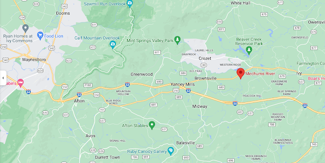
I have been trying to put the McNeely group living just east of the Beverley Manor or Borden Tract.  But using the water ways mentioned in the deeds it is more likely that they came through the  gap in the Blue Ridge Mountains later called Woods/Jarman Gapthat I-64  to settle just to the East of what is now Crozet.  In below map red marker just east of Crozet is Mechums River while green marker just above it is Beaver Creek.


1744 Albemarle County was formed from the western part of Goochland County

1745 Augusta County Court was established

1746-47        Peter Hairston was a member of Reformed Presbyterian Church in Ivy Creek, Virginia

Oh, my.  this is fun!  When I googled the above church I found a history of the First Presbyterian Church in Charlottesville....this is worth reading!  https://faithconnector.s3.amazonaws.com/firstprescharlottesville/files/resources/fpc_history_2nd_edition.pdf

I am not going to copy the entire article, but very exciting is the list of early Presbyterian families:

Mountain area of northern Albemarle County, there were five Presbyterian families: Anderson, Caldwell, Dougherty, Francis, and Pickens. In the Bucks Elbow Mountain area of Albemarle County, there were the following Presbyterian families: Davis, Grier, Kinkead, McCord, McNeely, Owens, Stockton, Wallace, and Woods. In the Rockfish Valley, just to the south, now in Nelson County, there were the families: Dobbins, Miller, Reid, Robertson, and Small.  I think we are zeroing in on our group!  The Red marker is Bucks Mountain!  So you can see that our group was living in the valley just below Bucks Mountain (shown with red marker on below map.)


Mountain Plains Presbyterian Church (Currently a Baptist Church)

The Rev. Mr. Craig, belonging to the Old Side Synod of Philadelphia, arranged for the transfer of the Rev. Samuel Black to the Valley of Virginia. In 1747, the Rockfish Meeting


9

House, and the residents of the Ivy Creek, located near the Ivy Depot, called Mr. Black as their pastor. The groups formed by the early efforts of Mr. Craig met in the homes of Mr. William Wallace, Mr. John Caldwell, and Mr. Michael Woods developed into the congregation worshiping at the Mountain Plains Meeting House at Mechums River. It is interesting to note that Ivy Creek circles Charlottesville, which developed later into the center of population of Albemarle County, from the west to the north of the City at a distance of approximately five miles. Beyond Ivy Creek to the west, Davis Stockton gave his initials, “D. S" to the locality of the meetinghouse, which served the Mechums River and Stockton Fork area of Albemarle County. Mr. Black ministered to all these groups.

I will guarantee that our McNeely family was right there with them!  It is my gut feeling that George McNeely and family had settled on the land that Robert eventually bought and had squatted there until Robert got around to buying the land.  Remember it was on Beaver Creek quite local to Michael Woods land.  

While googling these churches, there was a reference to Rev Edgar Woods book which can be found on line at:  https://archive.org/details/albemarlecountyi0000wood


Another book that was mentioned in the history of the First Presbyterian Church of Charlottesville is a book by John Hammond Moore which can be read at Archive.org:


https://archive.org/details/albemarlejeffers0000moor/page/n5/mode/2up


The reason this book was mentioned is that Mr. Moore says that the D.S. that is used for one of the Presbyterian Church locations near our McNeely family probably stands for Dissenter rather the initials of a man living in the area.


Thursday, June 1, 2023

Robert Alexander

I am working on both my own Scotch-Irish Ancestors at the same time I am working on papers for a prospective member of the Colonial Dames.  In spite of the fact that her husband is telling me that the Robert Alexander that I am looking at is likely not her ancestor, I have found myself quite interested in this Robert Alexander.  From Hildebrand's map I have taken a screen shot of the southern part of Beverley Manor:


Robert Alexander's School is affiliated with the old South Presbyterian Church.  You can see on below map that it is located as far south in the Beverley Manor as one can to.  Absolutely bordering on Borden's Grant.  The old and New Providence churches split over difference in beliefs of hymn singing and revival.  The Old Church continued to worship  in quite traditional and serious ways.

Robert Alexander, John Handley and Patrick Hays are mentioned in the same road orders.  They were friends and neighbors.  Below is found in Chawkley

Page 437:  Petition for road from Joseph Kennedy's Mill to John Huston's, and from John Huston's to the great road from Timber Grove to Woods Gap: James Hill. Joseph Kennedy, John Wilson, James Eakin, John Handley, William Wardlaw, William Lockridge, John Edenston, William McConnell, Walter Eakin, Robert Stewart, Robert Dunlap, Andrew  Duncan, John Huston, Samuel Huston, Robert Alexander, Patrick Hays, John Montgomery,. Andrew Steel, John Stewart 1751-1752

 The information found in a book in the library of W&L gives credit to Robert Alexander for having established the academy in 1749 that was the beginning of W&L University:


Sunday, May 28, 2023

Tuckahoes and Cohees

Ronald, one of my Morrison buddies has folklore in his family that his Morrison line was Tuckahoe Dutch.  So I am always looking out for the use of the word.  I am reading Waddell's Annals of Augusta County tonight and here is what is said on page 27:

At an early day, the people living on the east side of the Blue Ridge received the soubriquet of Tuckahoes, from a small stream of that name, it is said, while the people on the west side were denominated Cohees, from their common use of the term "Quoth he" and Quoth her" for "said he"

Paxton/Paxtang Pennsylvania and the Michael Woods family

 I do not want to forget that I have a slideshow named McNeely that has more information on this as well as a pages document named Michael Woods family that I should look at if I am reviewing this information at a later time.  I did not transfer all of the information from these documents while working on this blog post.  

I have been working a bit on the FAN club of the McNeely family.  Elizabeth Shown Mills is the researcher who introduced the term and I am probably not saying it perfectly but you will get the idea:  Family/Friends, Associates, Neighbors of the family that one is researching.

I have particularly been looking at Michael Woods because of the fact that when Robert McNeely died in 1764 in Albemarle County, there is no doubt that the Woods family are a very important part of the FAN club.  The witnesses were: 

Michael Woods, Jr.  James Woods, and William Woods.  The will was dated September 1756


 I chose Michael Woods because he seems to be well known in many accounts while our McNeely family is not mentioned as much.  So I found by good luck the following a week or so ago:


Paxtang/Paxton is a suburb of Harrisburg today

This was in a card catalogue of some sort for Mennonite records.  Definitely Michael Woods was not Mennonite but likely he had neighbors or relatives who were or had married someone connected to the Mennonite church.  This is definitely OUR Michael Woods.  And the important piece of information is that he arrived in Lancaster County 1724 and stayed there for 10 years before his move to Goochland County.  And he was living in Paxtang which is also called Paxton.  This area is no longer a part of Lancaster County.  However in 1724 Lancaster County was pretty much everything west of the three original Counties in PA.  Paxtang/Paxton is now a suburb of Harrisburg and is in Dauphine County.  But it is highly likely that the families who moved with Michael Woods and group had either come from Ireland with him or had met him in Paxtang/Paxton….so I think it is fun to poke around to see who we can find there.  I am starting this search by buying a book called A History of Paxton Church by Morton Graham Glise.  When I finish reading it, I will share what I have learned.  It is a very interesting area that was full of Scots-Irish in the early years.  Our McNeely family were gone by the time the incident with the Paxton Boys happened, but if you read about that incident you will get a feeling for the area.  There were all sorts of Indian problems in the area.  Particularly the Scots-Irish and the Indians had problems.  And it is possible that the Indian problems were part of what caused Michael Woods’ group to move to Virginia.


The Next is from:  https://www.lowerpaxton-pa.gov/248/History


Paxton Township was created in 1729 within Lancaster County. Organized long before the City of Harrisburg, it was at that time about the size of Dauphin County.  

and

Settling within the township during its colonial period were many German and Scotch-Irish immigrants. They established several farms and settlements throughout the area which eventually developed into the township's three villages. 


A few thoughts that I don't want to loose:


On page 14 is an explanation of the Scotch-Irish that includes: "England would have a colony there that would be an asset and a helpmeet,  This plan was put into effect with attractive offers being made to those who would leave their native Scotland, or England, and move to Ulster.  Those wishing to make the move were carefully screened.  Certain standards of selection were strictly set forth.  This was no venture for the poor, nor for the timid, nor for those whose political loyalties to the British Crown were questionalble. Certain conditions were set forth for the "Undertakers""  The "Undertakers" were those who had accepted the challenge to migrate to Northern Ireland.  In exchange for large tracts of land, 1000 to 3000 actres, the Undertakers agreed to build a stone or brick house, a barn, a fortified enclosure and enough weapons to arm 24 men.  A nominal yearly rent was to be paid to the Crown.  Contrary to original plans, more Scottish people responded than English; but the plan was successful.  The Scots who responded were almost exclusively from the Lowland area.  They were people who themselves had long been accustomed to confrontation with clansmen who were raiders, pillagers, cattle thieves, rapists and murders.  Henry Jones Ford says in his books, The Scotch-Irish in America p. 91 "Hardened by perpetual contact with barbarism, the Lowlanders had no scruples about making merciless reprisals.  The people were hard; the law was hard. The Scots were as fit as any people in the world for such an undertaking.

The next paragraph says:  The list of Scottish applicants who first received Ulster allotments in 1610 contains many family names similar to those who eventually made up the roll of Paxton Church.  We find names such as:  James Hamilton, Andrew Steward, Thomas Boyd, George Murray, John Brown, Alexander Cunningham, William Baillie, John Craig, Robert Lindsay and many others..... 

Now, all of that said, if the McNeely family was from Antrim, none of the above applies to them as the Counties of Antrim and Down were privately settled and not a part of the plantation.  Among the many men who acquired land in County Antrim, two, Arthur Chichester and Randall MacDonall, were responsible for encouraging the most people to settle there


Sunday, May 14, 2023

Mero district of TN and William Morrison's family

 The Mero District of TN is the part of TN outlined in Red in the below map.  It is where Nashville is now located.  


William and Rachel Witcher Morrison may have moved to Middle TN at one time.  There are a couple of things that point to that possibility.  One is that Patrick Henry (son of William and Rachel) said that he was with a group that tracked Indians who had stolen their horses in Giles County, Va to what is now the Salt Rock Community in Cabell County.  They found the horses and returned home.  Patrick Henry liked the area so much that he and his brothers and sister traveled through the Cumberland Gap to settle at Salt Rock in what is now Cabell County, WV.  

If you look at a map, you will see that it makes no sense that the family traveled through the Cumberland Gap from Pittsylvania County to what is now Cabell County.  This statement only makes sense if the family had traveled through the Cumberland Gap between middle TN and Green County TN or Pittsylvania County, VA....and that that place had made a big impression on Patrick Henry.  So that he included it in his information about his families move.


The Cumberland gap is located just north of the word Tennessee that is farthest to the right in the above map.

The other piece of information that would lend credence to this idea is information given to me by Luan:

There were so many William Morrisons in what was briefly "Mero District," perhaps as many as six or seven from the late 1790s. I couldn't attribute any of the other Morrisons there as being H2s. But it wasn't for lack of trying.

The William Morrison, of Mero District, attorney for Patrick Morrison in Greene County in 1795 is the link of a William Morrison to H2 Patrick and to middle Tennessee. I believe that is why the Roane County loose papers said Patrick's son William Morrison went west, unless there was a family story of William's migration.

Luan

I am not clear when William and Rachel left Greene County TN to move to Metro district (if they did).  I do know that Daniel Witcher (father of Tandy Witcher) was living in Smith County, TN when he died in 1815.  Smith County would fall into the Mero District of TN.  Daniel would have been an uncle to Rachel Witcher Morrison.  It is possible that several relatives had all moved together to Mero district.

But now the piece of information that I wanted to save.  I have told the story that the reason that William and Rachel Witcher Morrison moved back to Pittsylvania County was that Rachel said to William:  "Honey, I want to go home.  I am tired of worrying about the Indians.  My father and mother are getting old.  I want them to see our pretty children.  I want to go home and take care of them,"  And William said OK.  Of course, that is made up....but it has been my story.  Here is information supporting the part about the Indians:  (you may have to manipulate it in order to read it...I had to make it large to be readable)


Friday, May 12, 2023

Scotch-Irish in the Shenandoah Valley

I am reading The Tinkling Spring Headwater of Freedom by Howard McKnight Wilson.  On page 19 I found the following:  "Between 1732 and 1738 the lands of the southern shenandoah Valley were settled without formal claim or title.  However, the settlers staked out the lands each desired and settle upon them.  Though they built their cabins and began to improve upon the lands, in the absence of claims they constituted a "Squatters Right".  When Beverley secured the patent covering the same territory, it appears that he dealt peaceably with the settlers.  Beverley needed settlers and the settlers needed legal titles to their homesteads, so he and the early settlers traded for an average of one English pound for forty acres.  however, when the Augusta County Court was established in 1745 the price to new settlers was almost doubled.

Later in the book (page 25) the author says that William Beverley had patented Beverley Manor in 1736 and began selling land in 1738.  Page 25 also lists families and where they were living prior to the selling of the land.

Then next page explain that Beverley had applied for his land in 1732.  Soon there were neighboring settlements to the west and the southwest.  The Borden grant was southwest.  The Ephraim McDowell Clan arrived in Beverley Manor in the fall of 1737.  Benjamin Borden followed only slightly after this date and received hospitality at the McDowell's for the night.  He asked them for assistance in locating and settling lands to the southwest of the James River.  Benjamin Borden had already been granted land by the Virginia Council.  John McDowell (son of Ephraim) was a surveyor.  He agreed to guide Borden to the land he sought in exchange for 1000 acres within the Borden claim.  In Nov 1739 Borden obtained his 92,000 acres for 92 settlers.

In the same period, William Beverley was handling another claim before the council at Williamsburg for 30,000 acres on the tributaries of the James to the west of the Beverley Manor.  He was in correspondence with Captain James Patton of Scotland concerning the securing and transporting of settlers.  Did James Patton bring mostly Scotch-Irish or did he also bring Scots?

It is very interesting to me where James Patton was bringing in his Scotch-Irish passengers.  His ship would dock at Hobbs Hole.  It took a bit of research to figure out where that was.  Unfortunately I could not find documentation for this idea.  And there were other possible ports mentioned for the docking of James Patton's ships.

However, Tinkling Spring book says that the tradition that Patton made numerous trips to Hobb's Hole in Virginia, bringing Scots from Ulster, Ireland is not borne out by the shipping returns on the Potomac 1735-1756, where ship owners and ship masters were listed on both incoming and outgoing ships.  Patton's name is found there only once and that, as master of the ship on which he brought his family among the ship's sixty-five passengers.

Those who disembarked upon reaching Hobb's Hole on the Rappahannock Ricer were Patton and wife and two children, John Preston and wife and four children, and some fifty-six personal and indentured servant. It is thought that these last were imported to seat the 30,000 acre tract on Calfpasture river .  After this one-way voyage another ship master returned the ship and the Patton family stayed in Virginia.


And the maps on this blog post will help visualize the land described in the opening paragraph.

http://marshamoses.blogspot.com/2022/04/shenandoah-valley-and-rockfish-gap.html


Monday, May 8, 2023

Sunday, April 2, 2023

Atkinson

I am cleaning out my inbox this morning and deleting old e-mails that had information in them that I am not quite ready to lose.  I am almost certain that this URL came from Nancy Wooten....but it is about the Atkinson family: 

https://dnaconsultants.com/cherokee-unlike-other-indians/

I barely skimmed the first of the article.  But the part that you want to read if you believe that you connect to the Atkinson line is in the blurb labelled Cherokee Unlike Other Indians…..Scroll down until you see the Adkins surname in bold letters.

  And here is what I wrote at the bottom of the e-mail that I sent to the Morrison google group:  I am a bit blown away by this article….I have to think about it a bit!  There are just enough facts that are familiar to me to get my attention!  I do believe that I descend from this Atkinson/Atkins line.  I believe that William Morrison and his wife Rachel Witcher were living on land that William Atkinson had given his son-in-law, William Witcher, when William married daughter, Lydia Atkinson.  That is William and Rachel received land from her father that her father had received from his father-in-law.  And I continue to believe it most likely that I descend from these people!  I just can not prove it yet.  However, I have been looking lately at the area around Henrico, Chesterfield, Cumberland and I see Atksinsons there….not likely to be the same Atkinson family that came into Philly area…..But we’ll see, huh?  Any thoughts for me on this from those of you who have Atkinson/Atkins connections?  We already know that Owen Atkinson/Atkins was traveling with our group to the Wautauga/Nolichucky area as he was among the signers of the petition with our Morrison men.  And here is what the article says about the Adkins family (below).  The William with the accumulation of wealth is my 7-gr-grandfather/

Adkins . . . is a family heavily intermarried with the pioneer Coopers, Blevinses and Burkes from Wayne County, Kentucky.  They came from Pittsylvania County, Virginia, an important staging area for the movement of Melungeon families along the northern and eastern boundaries of the Overhill Cherokee. The family is traced to a James Atkinson, a Quaker who came to Philadelphia in the 1600s, probably from a seaport in Wales. His great-grandson William Adkins left a will dated Jan. 22, 1784 and probated March 15, 1784, detailing an accumulation of wealth, and was buried near Cooper’s Old Store, Pittsylvania County. William’s son Owen was born about 1750 in Lunenberg County, Virginia (parent county of Pittsylvania) and died in Watauga, Hawkins County, Tennessee about 1790. He married Agnes Good/Goad, from the same family that provided a spouse to Valentine Sevier (1701/02-1803). Good is the English equivalent of Shem Tov, Buen, Boone, Le Bon and other names for those bearing the “good name” of King David. Valentine and Agnes were the parents of John Sevier, the first governor of Tennessee. One of his sons, Valentine, married Sarah Cooper. The Seviers can be traced to Don Juan de Xavier of a Sephardic family who took refuge in Navarre during the Spanish Inquisition.

In 1836, Benjamin Adkins built a log mill on the Little South Fork of the Cumberland near Parmleysville, Kentucky, made of huge squared logs. This mill, with rifle slits on two levels, is still standing. He left a will in 1839 showing $10,000 in debts owed him and an estate of great value. Numerous family members moved first to Sequatchee (Marion County, Tennessee) and subsequently to Sand Mountain and to a hidden cove at the foot of Fox Mountain (named after Black Fox) called Anawaika, or Deerhead, on the Georgia state line. Some proceeded west to Arkansas. William E. Adkins (about 1828-1862) married Susan E. (Sukie) Cooper (about 1831-1901), the daughter of Isaac and Mahala Jane (Blevins) Cooper, April 20, 1847, in Henry County, Tennessee, and descendants filed unsuccessful applications to be enrolled as Cherokee in Indian Territory. Memories of their Cherokee ancestors ran thin, but Steve Adkins of Arkansas  recalled in 2001, “When I was little my Great Grandma Adkins (Virgie Stanley) use to tell me stories about my Great Grandfather’s (Arthur ‘Aud’ Adkins) Grandmother. She said her name was Sukie and she was a Cherokee Indian. I later found out that ‘Sukie’ was a nickname for Susan. She also mentioned the name Mahala Blevins.”  


Monday, March 27, 2023

The three Morrison brothers in the Revolutionary War

 Many of us in our Morrison h2 group descend from one of the three Morrison brothers (William, John and James) who went off to war together  and were fortunate enough  to all return together.  The three served in the Virginia 6th Regiment from late 1775 until their honorable discharge March 16 1778.  I have not looked at every single one of the documents available for all three brothers on Fold3, but every pay roll that I viewed showed all three of the brothers being paid for that time period.  

I will show some of the slides I had prepared for our Morrison h2 zoom Meeting in March 2023. We became so engrossed in our discussion of yDNA and all things Morrison that we did not end up talking about the Revolution.  It was a good evening.

The first slide just gives a place to start with the Boston Tea party:


English Parliament responded to the Boston Tea Party in 1774 with the Intolerable Acts, or Coercive Acts, which, among other provisions, ended local self-government in Massachusetts and closed Boston's commerce. Colonists up and down the Thirteen Colonies in turn responded to the Intolerable Acts with additional acts of protest,

And most importantly what we would now call patriots, responded as a group by Convening the First Continental Congress in Philadelphia which petitioned the British Monarch for repeal of the acts. 
The First Continental Congress also coordinated British resistance in the fall of 1774.  

By spring 1775 the British monarch had failed to respond to the petition and 
the Second Continental Congress met in the Pennsylvania State House (now 
Independence Hall) in early May 1775.  By June 14, 1775 the Second Continental Congress had agreed
to raise troops from 12 of the colonies and to provide help to Boston.  The troops 
would be under the command of General George Washington.  The convention
also agreed to encourage counties to form militias.


The two counties of Berkeley and Frederick in Virginia were tasked with raising the troops allotted to
Virginia to send to Boston for the aid of Boston.  It is clear by looking at the map that these troops were the closest to Philadelphia and thence to Boston of any troops in Virginia.

Since this next information does not affect our Morrison brothers you probably wonder why I am adding this to the blog post.  I bought a book about Virginia's Continentals.  Virginia's Continentals are not the men who served in the militia nor were they minutemen.  These are the men who volunteered to fight with Washington and were paid $6.25 per month.  They were not volunteers.  They were members of the Continental Army.  This is indeed the status of our Morrison brothers.

Among the very first pages in the book, the author explains this about the men from Berkeley and Frederick Counties:  The arrival of the continental rifle companies (these men from Berkeley and Frederick Counties) in late July and early August sparked a wave of excitement among the New England troops outside Boston.  Riflemen were largely unknown in New England and their appearance and reputation made quite an impression.  Surgeon's Mate James Thatcher of Massachusetts described these men as

Remarkably Stout and hardy men; many of them exceeding six feet in height.  They are dressed in white frocks or rifle-shirts and round hats,  These men are remarkable for the accuracy of their aim; striking a mark with great certainty at two hundred yards distance.  At a review, a company of them, while on a quick advance, fired their balls in objects of seven inches diameter at distance of two hundred and fifty yards.  They are now stationed on our lines, and their shot have frequently proved fatal to British officers and soldiers who expose themselves to view, even at more than double the distance of common Musket shot.....scores of troops armed with muskets join in, firing smoothbore weapons which were far less accurate than the rifles.  When some of the New England troops marched to Quebec, there were three rifle companies and ten musket companies.

Mid October, in Virginia Colonel Henry assigned the fifteen companies of Regulars who had gathered or were on there way to Williamsburgh to their respective Regiments. The author names the captains of each company and the counties from which their men came,  This is on pages  16-17-18.  Our Morrison brothers would have been in Captain William Campbell's company from Pittsylvania District made up of Pittsylvania, Botetourt, Bedford, Fincastle Counties. The authors says that Green's, Campbell's, and Gibson's companies were the rifle light infantry.  Although it is likely that a number of men in the remaining five companies also carried rifles, most carried smoothbore muskets and the companies were designated as line companies.

So the information given in the two separate places in the beginning of the book would tell us that indeed William, James, and John were in an elite group within the Virginia Continentals.  It is not surprising that these men from the frontier area of Virginia brought their rifles and knew how to use them.  And that the rifles were an important part of the fight against the British.


Tuesday, March 7, 2023

Washington DC

 I am in DC tonight on my way to Boston,  I am staying at the Lombardy Hotel.  I ate dinner in the dining room all by myself.  I ate late and the room had cleared out.  So the waiter felt he might entertain me a bit.  And he did.  My favorite two stories were the following.  After the fires in this area during the war of 1812.  President James Monroe moved out to this area which is foggy bottom,  He lived in the house that is next door to the hotel,  The hotel was not even a distant plan at the time.  So I went outside after dinner to take a photo of the house.


The photos above are taken from website and show my hotel....you can just barely see the house that James Monroe lived in just above the word:  outside.


Very fun!  The house that James Monroe lived in while president!


Sunday, February 26, 2023

Virginia 6th regiment of the Continental Line Orderly Book

 In preparation for out Morrison zoom meeting in March, I am listening to the presentation made by Craig Scott last year for the DAR Genealogy Lecture Series--Revolutionary War era Genealogy.  Craig mentioned checking to see if there are any unit histories about the unit that your ancestor was a part of.

Wow....how crazy is it that I have not done any of that kind of reading.  So I googled The Virginia 6th Regiment of the Continental Line Books.  And guess what popped up first!  the Orderly Book has been digitalized by the Huntington Library in California:


https://hdl.huntington.org/digital/collection/p15150coll7/id/29066

and on Hathi Trust is a transcribed copy with an excellent introduction


but Ronald explained this is not the same book that I copied last year at the DAR library.  The book that I copied there was maybe a day book?  I can not remember.  But neither Ronald nor I found anything about the Morrison men in the book.

and I bought the book:


When the Revolutionary War erupted in Massachusetts in April 1775, no American army existed. Each colony had its own militia that required inhabitants, typically free men between the ages of sixteen to fifty years old, to defend the colony when needed. Few colonists imagined prior to 1775 that such colonial militia would be pitted against the professional regulars of the British army, but that is precisely what occurred as a result of the bloodshed at Lexington and Concord.

Within two months of the start of the war, the Continental Congress moved to strengthen the colonies by creating a Continental Army under General George Washington of Virginia. Aside from providing a commander-in-chief for this new, regular army of American troops (who were to serve until the end of the year), Virginia initially supplied just two companies of riflemen to the continental army.

This soon changed, however, as both Congress and Virginia realized the need for vastly more continental soldiers. By the end of 1775, Congress called upon Virginia to supply six continental regiments of over 700 officers and men each to the Continental Army. Within another year, that number more than doubled to sixteen regiments and also included two regiments of light dragoons (cavalry) and one regiment of artillery.

This book explores the formation and service of Virginia's continental troops during the first several years of the Revolutionary War. 


Saturday, February 25, 2023

How does John Hensley fit into the Hensley tree?

 Don't ask me how I happened to look at my Hensley family this morning.  Sometimes my ancestors seem to speak to me?  I have totally convinced myself that John Hensley who married Milly and lived in Pittsylvania County, Virginia during the Revolutionary War had Foster paternity.  And when that happened, I quit looking at him and turned to other lines.  But this morning when I sat down at my computer, I pulled up the Ancestry tree of Suzanne Baird.  I know without a doubt that Suzanne is a fastidious researcher and has spent MANY hours on the Hensley family that I have always believed to be my family.  And there it was:  a new theory about my 5-gr-grandfather, John Hensley!

This is only a theory.  After I run it by Suzanne and Marty Grant I will either incorporate the new theory into my data base or I will totally erase this post from my blog when they shoot holes in it....such as Benjamin and Elizabeth Hensley had no female offspring.  Here is a screen shot from Suzanne's Ancestry tree:


What do you see?  That Benjamin Hensley and wife, Elizabeth Hickman have the last son, John almost 25 years after the birth of their first son, William.  It is not impossible.  But is it not a possibility that there were some daughters in the gaps between the men's births?  And that one of those daughters might have been born in the gap between 1727 and 1735?  And that it is daughter of John and Elizabeth who gave birth to John Hensley in 1751 after a relationship with a Foster male?  I have always known that the Hensley family and the Foster family were intertwined in Albemarle County.  Oh my, this would be the best of all scenarios as I would not have to give up my connection to the Hensley family.  

Ok, first I will run this by Marty and Suzanne to see if they can shoot holes in it before I spend more time on this thought.  

Wednesday, February 22, 2023

Where did John and Milly Hensley live in Pittsylvania County, Virginia?

I was explaining to Ronald where John and Milly Hensley lived in Pittsylvania County and decided to put it on the blog because I think I never added it to the other blog post.  From my data base:

10 Dec 1785 between John Henslee of Pittsylvania and Harmon Cook of Pittsylvania 50 pounds, a parcel of land containing by estimation 110 acres on both sides of Potter’s Creek.  Signed John Henslee….no witnesses.


We know from our trip to Pittsylvania County with the Morrison h2 group that Patrick Morrison's land is located on the below map at the spot where Frying Pan Creek crosses route 40.  Potter Creek also crosses Route 40 a very short distance west from where Patrick Morrison lived.,  You will see the red marker below showing Potter Creek.  It begins a short distance south of Route 40 and flows northwest until it flows into the Pigg River. .....The land that John Hensley is selling could be any where along the Creek...but no matter where he is a close neighbor of Patrick.