Monday, October 23, 2017

Signature of Uncle Benjamin

I took a photo of the document that Sandi Vaught and I found in Orange County, Virginia in September to share with Elaine.  It is a copy of the marriage bond that Uncle Benjamin signed when he was about to marry Mary/Polly Bickers.  I decided to put the copy on this blog just to make it easy to find.  

Benjamin is very special to my research as he seems to have acted as a father to my 3-gr-grandfather in their lifetimes.  Benjamin's will leaves much of what he has to his NEPHEW Thomas R. Hawkins.  Benjamin and Mary/Polly Bickers Hawkins did not have children of their own.  When Polly's father Nicholas Bickers died he left her only $1.  Not because he didn't love her.  But because she had no children of her own and she was rich while his other children were poor.  I love Nicholas for having left that will!

Sunday, October 8, 2017

Cabell County Morrison and Hensley family

I wrote on this map while reading Carey Eldridge's annotated Census of Cabell County for 1850.  Patrick Henry Sr., John Hensley, Samuel Hensley, and James Morrison who married Frances Thacker as well as Ralph Smith who married Viola Morrison were all living in this same area.  This area of land is just south of Barboursville and quite close to Martha.  However, it the farms go south towards Salt Rock from Martha.  By 1850 the land on which Solomon Hensley lived fell into Wayne County (formed from Cabell in 1842.  Bird Hensley's land was just a bit farther south from this area shown on this map after he moved back from Illinois with his family just before the census of 1850.


Dennis Hensley who descends from Samuel Hensley (Oldest male in Solomon's home in the census of 1850) told me that ....hmmmm can not find that information this morning.  I'll try to give Dennis a call to find out what he told me.

Saturday, September 30, 2017

Underground Railroad

I spent this weekend in Richmond, Indiana attending the Ohio River National Freedom Corridor Regional Underground Railroad Conference at Earlham College.  I go home feeling as if my life has been enriched by all that I have seen and heard.

Friday was spent with a small group touring the best historical sites in the area.  In the morning we visited the Wayne County Historical Museum.  Oh, my.  It is an exceptional museum.  Richmond had the good fortune to have attracted men who made a great deal of money in the 1800s making such things as farm equipment and lawn mowers.  A lady married into one of the families only to find out that her husband was bi-polar.  He was institutionalized in Cincinnati for much of his life.  This woman loved to travel and did just that.  She bought treasures that she brought home with her.  The museum is full of her treasures as well as many examples of articles made and/or used in the Richmond area.  There is even a real Egyptian mummy.  There is a wonderful story that a man who had been president of the Fisher-Price company and is now retired heard of the need to display the mummy in an appropriate way.  He told his wife of the need.  It turns out that she is an Egyptian expert and the two of them took on the job.  They have volunteered to develop an Egyptian room that is quite amazing.

Here are a few photos of some of my favorite things in the museum:


The afternoon was spent visiting the Levi Coffin House in Fountain City.  When Levi and Catharine were living there, the town was called Newport.  Our guide told us many stories of the many black men, women and children who passed through this house on their way from Slavery to Freedom.  Two of the particularly interesting things in the house were an indoor spring-fed well that is in the basement kitchen of the house and several locations in the house that may have been used to hide the freedom seekers.  It is believed that the house was never searched.

In the upstairs bedroom that is believed to have been used by Levi's mother, there is a pewter bowl.  It is said that the bowl belonged to Tristan and Dionysis Coffin.  Levi and I share this couple as ancestors.  They are my 9th-gr-grandparents.  Of course, I had to have a photo of this antique!

Today was spent listening to speakers who shared research and stories about both abolitionists and freedom seekers.  The talks were wonderful!  I will try to capture some of the stories when I am not so tired.

I will also tell about having my passport stamped.

But I have to tell the one more event that took place at the end of the event!  We were treated to the premier of a new movie called All or Nothin'

4:30 pm     Exclusive Screening of World Premiere Film     All or Nothin'  
Loose Lecture Hall


The Ohio River National Freedom Corridor is proud to present a screening of  feature film ALL OR NOTHIN’ by director Charles K. Campbell.   The film offers a rare glimpse of the Underground Railroad.   Campbell challenges the traditional view that whites were the leaders and saviors while blacks their helpless nameless benefactors, when in reality they very often worked together as equals.

ALL OR NOTHIN’ dramatizes the remarkable journey of 28 enslaved Americans from Boone County, Kentucky through 4 states and 2 countries. Historians, librarians, and educators who have researched this event and similar escapes of the era have provided undeniable evidence that free and enslaved blacks, as well as white men and women were integral to the success of the Underground Railroad.  ALL OR NOTHIN’ is a dramatization of their partnership to assist freedom seekers escape bondage.

Meet writer and director Charles K. Campbell and his production team and hear how this story came to light and life on the big screen.

The film length is approximately 90 minutes.  We anticipate concluding the session at approximately 6;30 pm. 


The information about this movie is taken from the site:

http://www.ohiorivernationalfreedomcorridor.org/

The movie is well done!  It absolutely captured my imagination and brought the underground railroad in to perspective for me.  Below are a few of my personal photographs.  Much to my delight several of the actors watched the movie for the first time with our audience.  A wonderful event!  Some of the photos did not turn out, so I didn't get photos of all of the actors.  And the very close up of a most attractive actor is because he was sitting next to me and the photo was thus VERY close up.


The last photo is of Charles K. Campbell who is the filmmaker.

Monday, September 18, 2017

H2 Morrison family

This is actually the second part to the post that I wrote last night that is just below this post on the blog (scroll down and read that post first). I am trying to get in my head where each of the families lived during the Revolution or just before or after that time period.  In the below blog post I established where Patrick Morrison and William Witcher were living thanks to information from Ed Griffith and Travis Morrison.

Ed and I looked at the following book yesterday:

Property Lines from the Old Survey Books Pittsylvania County, Virginia 1746 to 1840.  (I looked this morning and this book is available from the Va-NC Piedmont Genealogical Society website):

http://www.vancpgs.org/contents/index.php

We believe that the plat shown on page 12 I of that book is land that is said to belong to William Witcher and is the land William Witcher mentions in his will when he leaves it to his daughter, Rachel and mentions Rachel's husband by name as William Morrison and says that "it is the land on which they now live".  Why do we believe this to be the land?   Several other deeds mention that Harmon Kook/Cook's land is bounded by Morrison.  And on this plat, Harmon Kook is next door neighbor.   Ed and I believe that there is another deed as well in which Morrison is named as neighbor.  But if I look for those deeds tonight, I won't finish this post.

Ed found a land grant (on Library of Virginia website) from the Commonwealth of Virginia dated 1782 in which William Witcher is being granted land that is 115 acres and is on the Pigg River and Harping Creek.  This plat of land is 115 acres.  The land is described in the land grant as adjoining William Witcher's own land. (I am reading this in May 2019....and need to clarify on a day that is less busy....the land that is labelled as William Witcher's own land came from William's father-in-law?) My best guess of where this land is located is shown on the map below Somewhere on the map bounded in part by Harpen Creek and also bounded by the Pigg River.  I'll reread Ed's land grant document to see if I can be more specific:

map


I believe that Harping Creek is most likely Harpen Creek on this map.  The other marker that makes me think this is the right place is that Sandy Level is found on the map in the right spot to be Sandy Level on this map....slightly northwest from the land that was granted to William Witcher and that William and Rachel Witcher Morrison were living on at William Witcher's death.

Ok, now that we have this land's general proximity, let me show you a map that compares where each of the three families were living:


The red marker isn't perfect for the land on which William and Rachel Witcher Morrison were living on.  But it is close enough to get the idea.  Rachel's parents lived at about the place where the rectangle with 635 on it is located.  If William was the son of Patrick Morrison his parents were living or had recently moved (need to look that up) about the spot where the 794 rectangle is located.  I definitely call this pretty close proximity.  I think that this is evidence that stacks up to swing the scales toward the opinion that William Morrison who married Rachel Witcher is the same man as William Morrison who is the son of Patrick Morrison.  I have a bit of mulling and pondering to do still, but this is a very good first step!

Saturday, September 16, 2017

H2 Morrison

This weekend was a homecoming event with a small part of our H2 DNA group.  We met at Smith Mountain Lake to do research on this family's Morrison group who lived in Pittsylvania County, Virginia during the Revolutionary War.  Luan explained to me that the family only lived in this area for about 10 years before, during and after the Revolution.  I think that the consensus of opinion this weekend was that they were in Amherst County before moving to Pittsylvania.  Then many of the family members had moved out of the area by the late 1700s and early 1800s on to what is now TN and WV.

There is some evidence pointing to the possibility that my 4-gr-grandmother,  Elizabeth Hensley connected to this family line.  The old researchers in Cabell County said that Elizabeth had maiden name Morrison.  And definitely she and her husband, Solomon, were in Pittsylvania County when their first son was born c.1810.

It was a great weekend with lots of research done by everyone in the group!  But more importantly it gave us a lot of time to talk and share ideas of theories of how our group fits together.  We know through DNA that our Morrison lines are matches who have a common ancestor somewhere in time.  My own DNA participant who carries the surname Morrison and matches the H2 lines is a man who now lives in Cabell County, WV where I live now.

 William Morrison is Ed Griffith's ancestor with wife Rachel Witcher (William Morrison is the ancestor of the Morrison family lines in Cabell County, WV).  I am editing this post in 2019.  William Morrison was the son of Patrick Morrison of Pittsylvania County.  Other sons of Patrick moved to TN and remained there or moved on further west.  William moved his family to what is now Cabell and Wayne Counties in WV.

So on this last day of the homecoming, Luan and I sat out to find the grave of William Witcher, the father of Rachel Witcher and the father-in-law of William Morrison.  Unfortunately I wasn't smart enough to have asked Ed Griffith how to locate this grave ahead of time.  Nor was I smart enough to have Ed's phone number handy.  All we knew for sure were the coordinates and the fact that the findagrave information wasn't right.  So I put the coordinates into Google maps and found a general location.  And we headed out.  After a few wrong turns, we ended up beginning to ask people standing in their driveways.  Finally one man became very excited and told us that we were on William Witcher's land, but that he didn't have a clue about his grave.  We decided that it was enough to be standing on his land.  The location was beautiful!  This area is wonderful!

Here are a couple of photos that Luan took that give one an idea of how lovely the area is.

The first is just a particularly lovely photo that could be almost anywhere in Pittsylvania County.

The second is actually taken by Luan while we were standing on the land that had been owned by William Witcher.  We were only about a mile or less from the spot where he and his family lived and where he is buried.  Luan took this photo while we were on the road and it looks towards Smith Mountain in the background.

.

To get back to the area, one follows route 40 (Gretna Road) west from mid Pittsylvania County until 635 turns to the left.  I certainly took Luan a much harder way to get to the area using my map.  It is only a short distance (perhaps a mile but less than two miles) from the intersection of 40 and 635 shown on the map below.


Luan and I were on the road labelled 635 on the above map when we talked to the man who said that the land that we were on had been Witcher land.  I would guess that we were pretty close to the box with the 635 in it.  The land was lovely.  


Travis drove us on Friday to the area on which Patrick Morrison lived. This land is on the south side of 40 on the map below (40 and Gretna Road are two names for the same road....this happens a lot in Pittsylvania County).   When we followed Travis, we were driving west on 40 (W. Gretna Rd.).  We crossed Fryingpan Creek and then turned into the land on the left side of the road.  Travis had a man locate Patrick's land on a modern day map and it was bordered by Fryingpan Creek and Highway 40.  So it sits right in that corner on the south side of 40 and the west side of Fryingpan Creek.


The below map is to show the proximity of the land of Patrick Morrison with the land of William Witcher.  

So if I have this correct, the lands of Patrick Morrison and William Witcher would have been about where the 635 is on the map below for William Witcher and just west of where the 794 is on the south side of 40 for Patrick Morrison.


Next, I want to add the land on which the Goad family was living in Pittsylvania County.  The Goads were intermarried with the Morrisons who moved to TN.  But we also have Goads here in Cabell County and I feel sure that they are the same family line.  In order to add this land to the maps, I am using the book that I bought from the 

Virginia-North Carolina Piedmont Genealogical Society

This books is available at the following site:


The book is Property Lines from the Survey Books Pittsylvania County, Virginia 1746 to 1840 by Roger C. Dodson

The Goad property lines are shown on page 13-I of the book. 

As best as I can figure, John Goad bought land in Pittsylvania  15 Nov 1750.   It was 400 acres on the north Fork of the Frying Pan Creek.  From looking at above book and comparing information to a modern map, my computations make it seem as if he was next door neighbor to the land that we looked at for Patrick Morrison:


So while Patrick would have lived in the area bounded on East by Fryinpan Creek and on the north by route 40,  John Goad lived sort of where Luster road is on this map.  I believe that his waterway likely was the fork shown crossing Berryville Rd and flowing into Fryingpan Creek to the east.  John Goad Jr. buys his land on Cedar Creek which is not shown on this map.

Last but not least, I am interested in where the land is located that William Witcher left to his daughter Rachel saying that it was the land on which Rachel and William Morrison now live.  When I showed the map to Ed Griffith, he immediately recognized the neighbor to the east as Harmon Kook/Cook.  Rachel and William sell it to Harmon when the leave Pittsylvania County for Cabell County.  William Witcher bought this piece of land 10 January1782.  It is 115 acres on the Pigg River and Harping Creek.  I believe Harping Creek to be called Harpen Creek on the below map:

When Rachel and William sell this piece of land to Harmon Kook/Cook in preparation for move to Cabell County, it is described as by Pigg River as it meanders Harmon Cook Senior lines and William Parers lines .....it is also described as being on the south side of Pigg River.  The survey book locates it in this general area as shown on above map.  If you will notice the funny small road marked 888 on this map at the very top, it will help place this farm in relation to those of the Witchers and Morrisons. Sorry the below map did not turn out better.  I will try to work on something that is better when I have time  


And also as I have time, I would like to try to locate where the Hensley's and the Fosters were living as well.  I believe it to be in this same area.  

When I did a google on route 40 to see if it is historically much as it would have been in the 1700s I found the following information 

With the frequent use of the road by John Hickey and his wagons, it soon became known as Hickey's Road, and kept that name for many years. By 1751, the road became so important that it was used as a reference point for land entries and surveys. Hickey's Road is shown on a map dated 27 April 1767, a plan of the division line between Halifax and Pittsylvania Counties, by John Donelson, Surveyor. The road crossed Pittsylvania County from east to west in a slightly northeast-southwest direction, and on 26 June 1794, the Pittsylvania Court used Hickey's Road as the dividing line for militia districts. The militia in the South District became the first regiment, and the militia in the North District, the second. A U.S. Department of the Interior Geological Survey map, surveyed in 1924, shows Hickey's Road west of Chatham.  I just didn't want to loose this small piece of information.


Thursday, August 3, 2017

One more story about spending time with my mother-in-law


I explained in a previous post that my mother-in-law has a bit of dementia.  However I spent last Saturday and Sunday afternoons with her and she was very well.  I had lots of fun hearing some of her stories.  I started pulling up photos and asking her to identify the people in the photo.  One of the photos that I pulled up is above.   I have since had another genealogy buddy, Josie Bishop,  identify the ladies in the photo.  

I asked my mother-in-law who they were.  She wasn't sure....not surprising since it turned out that they were Moses women (her husband was a Moses and she may have only met some of these women once or twice if at all). And definitely she would never have met them when they were this young as it is possible that her husband had not even been born at the time of the photo.   After a minute she said: "well the one on the right is Sarah!"  I looked and then looked again and then said:  "You are right!  That is Sarah!"  It turns out that the lady on the far right is Lida Fitzgerald Moses (the wife of A.L. Moses) who was my husband's grandmother.  I never knew her as an young woman.  But I am telling you that my middle daughter, Sarah, is her spittin' image!  And the small child in the front of the photo is a dead ringer for my niece, Meredith!

Sunday, July 30, 2017

Tunnel between Twin Branch and Davy in the coal fields of WV

I had been chatting with Patty Ament about her mother's memory of having walked through the tunnel from Twin Branch to school.  It struck a chord with me because I remember hearing my mother-in-law's story about the same thing.  Yesterday my mother-in-law had a very good day and we spent the afternoon talking about her years in the coal fields.  I asked her about the tunnel.  She said that there was a tunnel between Twin Branch and Davy.  It was a long way to go around the mountain to get from one town to the other.  The tunnel made the walk MUCH shorter!  So she would put her ear down to the train tracks to listen for a train, and if she didn't hear one, she would walk through the tunnel.  Here is what I wrote yesterday after chatting with Sue about the tunnel:
So I asked her about the tunnel today while I sat with her.  She was very lucid, so I believe that her memory on this is OK.  She said that there were two tunnels.  One was between Twin Branch and Davy.  The other was between Twin Branch and Maryville.  She used the tunnel between Twin Branch and Davy quite often.  She said that when she was growing up, the mine that was owned by Fordson Coal Company was called the Twin Branch Mine.  It was good work….plenty of work and the miners prospered.  They would go to Davy to spend their money and there was a row of stores in Davy including several women’s ready wear stores.  So Davy was the “big town” while Twin Branch was more of a place where people lived and worked.  She thought that perhaps Davy had 5000 people….we can probably look that up.  Sue’s family lived in Twin Branch.  Her grandmother whom she loved very much lived in Davy right along the railroad tracks.  Sue said that there was a road along the tracks and then houses all along the road across the road from the tracks.
Sue used the tunnel to visit her grandmother.  She also said that she used the tunnel on the way home from her afterschool job.  She was a babysitter and cook at a very early age for a man who was an electrician in the mine.  She would go home with his kids and watch them until he got home from work and have dinner on the table when he arrived.  
Sue said that sometime in her teenage years the union went on strike at the Twin Branch Mine.  The owners just shut the mine down permanently and the work was gone as well as the money.  I will try to blog this this week…..if you have anything to add, I am happy to add your remembrances.  I will look for a map and photos to add to the post.  marsha

Rucci Grocery store in Welch WV

My mother-in-law has a bit of dementia.  I am sitting with her today.  Yesterday we spent the afternoon looking at old photos so that she could identify some of the people in the photos for me.  So when I walked in today, her brain was reminded of her life in the coal fields in the early to mid 1900s.  Her first comment after we made small talk and had some Colonel Sanders was:  "I don't know why I got this notion in my head.  But I was thinking that Mrs. Rucci is closing her store.  I always get a lot of what I need from this store. " After quizzing her a bit, I figured out that she was talking about Welch WV.  She said that her mother bought a lot from the store as well.  So, of course, I googled the Rucci store and she agreed that that was definitely the place!


I found the photo of Mr. Rucci in his store on-line.  Someone had posted it on Ancestry.  Sue said that the store was close to where she lived and was in a large building of some sort.  Sue said that she he liked most of all to sell authentic Italian food that he bought from special dealers.

Later in the day, Sue added that her mother went in one day for a piece of pie.  Apparently they also served food in the store.  She said that two of the waiters were arguing and one of the waiters through a pie right into the face of the other waiter.

Saturday, July 29, 2017

Painted Caves in France

I am listening to a book called Before the Dawn tonight that is about DNA and the earliest beginnings of man.  I like the book.  I am listening to a chapter that mentions the painted caves in France and I wanted to make a note.  The earliest caves that have been discovered are:

The earliest known European figurative cave paintings are those of Chauvet Cave in France. These paintings date to earlier than 30,000 BCE (Upper Paleolithic) according to radiocarbon dating.


The cave has been sealed off to the public since 1994. Access is severely restricted owing to the experience with decorated caves such as Lascaux found in the 20th century, where the admission of visitors on a large scale led to the growth of mold on the walls that damaged the art in places. In 2000 the archaeologist and expert on cave paintings Dominique Baffier was appointed to oversee conservation and management of the cave. She was followed in 2014 by Marie Bardisa.
Caverne du Pont-d'Arc, a facsimile of Chauvet Cave on the model of the so-called "Faux Lascaux", was opened to the general public on 25 April 2015.[26] It is the largest cave replica ever built worldwide, ten times bigger than the Lascaux facsimile. The art is reproduced full-size in a condensed replica of the underground environment, in a circular building above ground, a few kilometres from the actual cave.[27] Visitors’ senses are stimulated by the same sensations of silence, darkness, temperature, humidity and acoustics, carefully reproduced.[28]

https://www.theguardian.com/travel/2013/may/26/prehistoric-cave-art-dordogne

https://archaeology-travel.com/thematic-guides/cave-art-in-france/


Saturday, July 22, 2017

Scotch-Irish and Clendenin


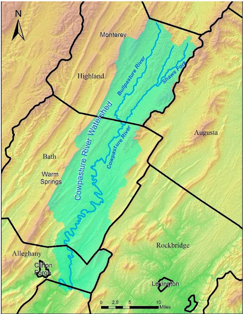
I found this map on-line one day and it has sat on my desk top.  I wanted to file it so that I could find it again.  But couldn't decide where that would be....so here it is on my blog.


With the research that I have done on the Clendenin family, I find that

One of the versions of the Clendenin massacre begins with this information: Archibald Clendenin lived in this valley (Calf Pasture) before moving to the lower Cowpasture where he died in 1749.  Archibald Jr was the most conspicuous victim in the Greenbrier massacre of 1763.  Charles, another son, gave his name to the capital of WV.  Morton “Rockbridge Co. VA. p. 89”  (don’t know if this is true or not.  Needs some research “someday”.  
and
 Archibald, Jr. a son by the first wife, moved to Greenbrier and was murdered by Indians in 1763.  His wife was a Ewing.  Five of his six children were also killed, but the wife escaped to the Cowpasture.  George and Charles seem to have been other sons.  The latter gave his name to the capital of West Virginia.


Sunday, June 11, 2017

Trip to the lower James River

I finally finished my Dames papers this past week.  All of that research on the Farrar family makes me yearn for a trip to the lower James River.  So much to see!  So I am going to begin to put a few things on my list for a future trip.

The idea was inspired by my having bought a new book this week that I am putting on my shelf as I have a very busy week.  Books that go on my shelf often then get overlooked.  This book is called the Invasion of Virginia 1781 by Michael Cecere.  I am thinking that it might be one of the books I might read at the time that I go since I will surely want to look at Revolutionary War sites on this trip!


From Wikipedia:

The Siege of Yorktown, also known as the Battle of Yorktown, the Surrender at YorktownGerman Battle or the Siege of Little York,[a][b] ending on October 19, 1781, at Yorktown, Virginia, was a decisive victory by a combined force of American Continental Army troops led by General George Washington and French Army troops led by the Comte de Rochambeau over a British Army commanded by British peer and Lieutenant General Charles Cornwallis. The culmination of the Yorktown campaign, the siege proved to be the last major land battle of the American Revolutionary War in the North American theater, as the surrender by Cornwallis, and the capture of both him and his army, prompted the British government to negotiate an end to the conflict. The battle boosted faltering American morale and revived French enthusiasm for the war, as well as undermining popular support for the conflict in Great Britain.[8]

Friday, June 2, 2017

Moore family in Orange County, NC and move to SC and GA

Lynn Perkins just sent an e-mail explaining about his Jackson family line.  I don't want to loose the thought that this family was in Orange County, NC and then moved into Wrightsboro .....and his wonderful story about one of the son's moving very quickly to preserve his "neck"!  As I was writing back to my wonderful Moore group, I decided to place the information here so that it is at my fingertips.  I will also link this post to the one that is already in place about Eno MM.

http://marshamoses.blogspot.com/2012/04/eno-cemetery-marker-dedication-just.html

Here is Lynn's reply to my question about his Jackson family:

Marsha, it was our, (Suzann, Rachael and Lp) line of Jacksons.  For fun and for me to write up my Jackson family notes I will go over again the Moore-Jackson connection.  It seems our Jackson line was a bit roudy.   Papa Jackson owned a tavern at the outskirts of Hillsborough where everybody met to cuss and discuss Gov. Tyrone mishandling of gov. The Gov. put out a bounty to hang one of the sons. Col. Benjamin Jackson of Rev. fame.  I may have his name wrong cause this is old and stale in me mind.  Benjamin had to leave in the middle of the night to keep his neck from being stretched beyond toleration.  He rode hard and fast to Wrightsborough. There were 4 brothers and a sister who ended up at Wrightsborough.  Out of all there were 5 men named Absolum Jackson.  I managed to eliminate 4 of them as not being the Absolum Jackson of the 1820 Jones County GA. Census.  The 5th was very elusive and hid out in the wills of Chambers County Alabama who I had been told contained no Moore relatives.  in the 1820 Census next door was Hedion More. 1 male and 2 females and no wife.  Next door was Absolum Jackson who had 2 right age for twins.  We knew Papa Moore lost his wife and had a set of twins, a brother and two sisters.  They started looking for Papa Moore and the twins in 1977.  Absolum Jackson who raised the twin boys decided to come out of hiding in the court house in 2000.  When Absolum Jackson of 1837 will, came out of hiding in the will book, almost every remaining mystery fell into place except finding and deciding which Richard in Alabama was the twin's family.  That is when I found Harry Moore and spent a rainy day in July fitting in the remaining pieces of the Idens and Richard Moore puzzle.Lp  Oh I forgot to tell you there was a David Jones on the other side of Absolum Jackson 1820 census Jones Co. connected to David Jones of Citalgarth and neighbor and trustee of John Moore's will 1719. Tis a small small world we live in.
Then here is what I wrote back to the group:

Ok….so that IS a part of your Jackson family that is buried in the Eno cemetery….May I please put this on my blog site so that I remember it if I ever manage to put together a homecoming in Wrightsboro?  That is my dream in the next few years.  I haven’t had much luck with the Orange County, NC area in reconstructing the neighborhood …..too much missing…..but I think that we can do this reconstruction with the help of the research that the group who rededicated the Eno cemetery and knowing who we find in Wrightsboro.  I think that the only reason we do not find the Moore group on that headstone is that the family was lucky enough to not have anyone die while they lived in that area.  

We do know that Richard and Sarah lived there.  Their certificate was for Cane Creek MM….but Eno was a preparatory meeting under Cane Creek MM. Someone correct me if you do not believe that this was the area in which they lived.  I ALWAYS want to be corrected!   I am not sure that any of us have agreed that we know for sure that Sarah’s maiden name was Jenkins.  Does anyone have that proof?  And I am not sure that the lady who sent me the below was correct in sorting out which Mordecai Moore it is found buying land in SC: Richard’s son Mordecai (my ancestor) or Steve’s ancestor Mordecai who was an uncle to my Mordecai.  I haven’t yet gotten that straight in my mind.  

The Moore family stayed in Berks Co PA at Exeter MM until 1755.  The certificates from Exeter were received by Cane Creek MM in Orange Co NC on 6-4, 1757, for Richard Moore, his wife Sarah (Jenkins), their son John and their daughter Prudence.  A receipt of certificate for Mordecai and Abigail Moore is not in the extant records for Cane Creek, but they had to have had one, since Cane Creek disowned both.  Abigail's dis mou was recorded on 8-4, 1764 and also on 8-2, 1766.  One of those is probably a transcription error, since there are several of those in the Hinshaw summaries (or a typo at the printer).  Mordecai Moore was disowned on 5-6, 1758, and Prudence Moore on 7-7, 1759.  On 11-7, 1767, Richard and wife (Sarah) and son James were granted a certificate to Fredericksburg MM, SC.  Bush River wasn't yet an MM, and Wrightsborough GA did not yet exist as a settlement, much less an MM.  The Wrightsborough plans were already in process, so the older Moores probably went straight there--they didn't stay long enough in SC to get land there (although son Mordecai did).  Fredericksburg MM was the nearest one for either the Bush River or the Wrightsborough communities as of 1767.  Son John Moore stayed in NC until 4-5, 1777, when he was granted a certificate to Wrightsborough MM (received there on 1-3, 1778).

Since we know that this time period in NC was the time period when Richard and Sarah’s children were marrying….and marrying out of unity for whatever reason, I suspect that my George McKinsey and Sarah Moore did not meet in NC….but rather in SC or Wrightsboro.  Sarah is the daughter of Mordecai and granddaughter of Richard and Sarah.  I suspect that they met through Richard and Sarah’s daughter, Abigail who married Nehemiah Thomas in NC (dis mou) and then moved to an area in SC very close to the Bush River MM.  Although from a Quaker family, Nehemiah obviously had been dis or had left the Quaker church before his marriage since Abigail was dis mou.  I don’t know this for sure….but it seems the most likely answer to the question.  George’s family had bought land in SC:

   George McKinsey settled in SC on 8 Jan 1773 as evidenced by a land deed.  It reads in part, George McKinsey of Craven County in the Province of South Carolina, paid 250 pounds to Thomas Shaw for 150 acres of land more or less, 8 January 1773.  This land was bought in the 13th year of the Reign of King George III.  Note: In 1683 Craven County as shown on the deed was one of the first couties extablished  in SC.  All three couties were later abolished.  This area was made District Ninety Six in 1769.  In 1798 it became the present county of Newberry, SC.

This land was just down the road from the farm on which Nehemiah and Abigail Moore Thomas lived. 

Wednesday, May 31, 2017

Memorial Day

Only one of my grandchildren accompanied me to decorate the cemeteries this year.  Kya is my buddy.  We visited both Woodmere where the Moses group is buried and also Spring Hill where the Hawkins group and ancestors of the Hawkins group are buried.


For my new found cousin, James Lewis, who is interested in the genealogy of the Hawkins family, I took a few extra photos of our mutual 3-gr-grandparent's graves:


Saturday, May 27, 2017

Hawkins Map of Kentucky

I did this map many years ago while working on sorting out all of the various Hawkins lines that moved from the Orange/Culpeper/Louisa county area of Virginia.  I am actually just putting it on the blog so that it is easy to find.  I have first put a smaller version in place.  With the larger version, you should be able to shift the map to zero in on various parts.  Many of these Hawkins families belong to Hawkins DNA family group #1.  Others seem to belong to other groups.  Some are still not placed in a DNA group in my own mind.  We all just chip away at figuring everyone out.

Friday, May 12, 2017

Goochland County

I am working on my Colonial Dames papers this weekend and thus I am looking at the Douglas Register  to use in proofs on generations from Louisa County, Virginia back to the Farrar family of Farrars Island.  The Douglas Register was transcribed and edited by W. Mac Jones in 1928.  At the time that he transcribed Rev William Douglas' records, he commented that the actual original book was in a good state of preservation.  His introduction says:

This book is known as the "Douglas Register" for the reason that it not only contains a record of Births, Chirstenings, Marriages, Deaths, and Funerals in St James Northam Parish and the county of Goochland, but in many instances in adjacent counties and others more remote.  The record also is not only for the period he was in charge of St James Northam Parish, but continues after he left that parish, on the 5th of September 1777, and went to live in Louisa County.  In fact he kept up the entries in the Register until 1797, and thus it covers a period of


 ninety-two years.

On the title page it says:  Being a detailed record of Births, Marriages, and Deaths together with other interesting notes, as kept by the Rev. William Douglas from 1750 to 1797.

And just below that it says:  An Index of Goochland Wills.  Notes on the French-Hugeunot Refugees who lived in Manakin-Town.

The reason that I am making notes in the blog while doing this project is that as I started reading, I decided I wanted some maps to help me interpret what I am reading.


And the above map suggests that these settlers came right up the James River just as those in Orange and Culpeper came up the Rappahannock and those in Louisa came up the North and South Anna rivers from the Pamunkey


I am viewing the Douglas Register on Ancestry.

Thursday, May 11, 2017

Very early settlement of New Jersey

My Moore group has been chatting about our Cureton ancestors.  James and Rose Moore's son John married Jane Cureton.  It is quite clear that Jane's family came over on the ship the Swan in 1685.  They settled in the Welsh Tract almost immediately.  However, we are not as certain how our Moore ancestors came to these shores.  We find James and Rose Moore in what is now downtown Philly by 1684....just two years after Penn had the city laid out.  Had they moved to these shores before and had been living elsewhere?  Did they move just in time to buy land in the new Philadelphia?  Our group is not sure.  We also are not sure just where they were living before they climbed on board a boat that brought them to our shores.

Wednesday, March 15, 2017

Very early Hawkins families

Elaine and I were chatting this morning about some of the early Hawkins families.  She mentioned all of the names that are found in the St. Paul's register that includes King George County and Stafford County, Virginia.

I bought that book.  I don't have time to look at it this morning.  I would guess that it is Hawkins' that connect to Thomas of Old Rappahannock County....but don't know for sure.  Here is the name of the book if I want to look at it on my computer at a later date.  It should be on Google Play and is among the bookmarks on my computer.  Oh, wow.....I need to spend some time on looking at my collection of books on Google Play....AMAZING!


The below map shows King George County and one can surmise where Stafford County is very easily.  I won't add another map.  Note that both are close to Fredericksburg which is at the falls of the Rappahannock River.

Friday, March 10, 2017

Jacob and Elizabeth Elliott in Pennsylvania

Ancestry just sent me a link to the copy of an original record that names the first four children of Jacob and Elizabeth Elliott and gives their dates of birth.  The record is said to be from the Menallen Monthly Meeting in Adams Pennsylvania.  I had not had this information before....well that may not be accurate.  If I had this information before, it did not sink in.  So this blog post is about where this Monthly Meeting was located and what it might tell me about proving parents for either Jacob or Elizabeth. [I saved this document to my Ancestry Tree]

Menallen  Monthly Meeting was founded in 1748 as a Preparative Meeting by the Religious Society of Friends (Quakers) and became a Monthly Meeting in 1780. It is an active spiritual community that supports its members and the surrounding community.  In addition to weekly worship, we have a monthly spiritual study group and other activities including community outreach.  Menallen Monthly Meeting (also known as Menallen Friends) follows the tradition of unprogrammed silent worship, and is a member of Warrington Quarter and Baltimore Yearly Meeting.  So it seems that it is still an active meeting.  
This is such a surprise to me as I had thought that the Elliott family had been located in the environs of Philly.  Instead the map below shows the location of Menallen MM:
From the website:  http://www.menallenfriends.org

In 1691, William Penn (a member of the Religious Society of Friends) founded a government and a society that welcomed all people and all religions. This tolerance attracted immigrants of varied religions and backgrounds, including many Quakers.  By the 1730’s some of these families moved to York and Adams Counties in Pennsylvania. The percentage of Friends (Quakers)was significant.  To support these new communities new Quaker Meetings were established, notably, Newberry (Redlands) Meeting in 1739, Warrington in 1745, Menallen Meeting in 1748 and Huntington Meeting  in 1750.


At the time that Jacob and Elizabeth's children were born, Menallen was a preparatory meeting:
to hold regular meetings and for several years to come all members of Menallen Meeting were members of Sadsbury Monthly Meeting.  However, upon establishment of Warrington Monthly Meeting in 1747, all Friends west of the Susquehanna River became members of the new Monthly Meeting.  There is a description of where the original and also the newer meeting houses were built at this same site. 

And from: http://thegenproject.com/quakers/meeting-info/baltimore-yearly/warrington-quarterly/menallen-monthly  


Menallen Prep

Menallen
Menallen Preparative was set up as in 1748 by Sadsbury Monthly, having been an Indulged Meeting since 1733. In 1748, the meeting became part of Warrington Monthly Meeting, the registers of which show that the first marriage to be conducted at Menallen in 1751. Menallen's earliest meeting house was a log structure, which they tore down in 1838, and rebuilt on a new property in Flora Dale, about a mile south of Bendersville. About 1890, that structure was replaced by the red brick building currently in use.


Records of Menallen Monthly Meeting, 1733-1993. Includes men's and joint minutes 1780-1963, women's minutes 1780-1891, vital records 1733-1991, Ministers and Elders minutes 1884-1911, and miscellaneous 1851-1993. So it does not look as if there would be more information available during the time that Jacob and Elizabeth were in PA.  By 1763 they had moved to North Carolina.  Which brings me to the reason that I had assumed that they were from Warrington MM.


1763, 11, 26.  Jacob (Ellott) & W& ch, Jacob, Elizabeth, Hannah, Israel & William rocf Warrington MM, Pa, dated 1763, 9, 20 (I have a copy of the original MM records for this) This is found in the records of New Garden MM in what is now Guilford County, NC.  It would have been Rowan County in 1763

They would have taken a certificate from Warrington MM because at the time Menallen was not yet a MM.  It was still just a preparative meeting.